A box at the bottom of the UI could be opened if so desired which has all current targets in the sequencer, clicking one of the targets puts it’s specific visual data on the graph to view, select another and that targets data will be displayed, a checkbox could also be in this list somewhere which could tell SGP to display all targets at the same time if it could be useful.
Checkboxes or a little dropdown box with selectable options (more sensible) could control what is actually being displayed at any one time. Some people like the confusing hot mess of lots of visual data at the same time and others, like me, prefer to only show certain data to avoid clutter, might be a good option for the future and then it’s the user who decides if they want clean or hot and messy.
Re-adding comments ai had included in another post. It would be useful to also have some information / control in relation to Azimuth:
“The altitude and planning tool looks great. One suggestion I would have is to incorporate over time user azimuth constraints. Indeed, many of us do not have 360 degree visibility and deal with balconies, trees etc…
One nice solution would be to add as part of your location profile an azimuth mask. It could be quite simple with a list of coordinates (azimuth, minimum altitude).
For example if my tree is blocking altitude below 60 from az 30 to 40, the file would indicate:
0-90
29-90
30-60
40-60
41-90
360-90
The planning tool would take this into account as an additional constraint. I really think this would immensely simplify life for all of us who don’t have a nice observatory with clear access to the sky…
I was thinking that being able to set start and end times relative to astronomical sunset/sunrise would be very useful - these change around 2 mins per day here, which means night can be 30min longer in a week’s time
Actually, perhaps better, a drop down, with 0, Civil, Nautical and Astronomical as the options, maybe in user/location menu items which either repopulates with start time based on drop down, with a small icon/indicator which lets you see which has been selected in the target setting windows.
Obviously, then manually changing start time turns off the Civil, Nautical and Astronomical option?
How about adding the ability to draw your horizon line? I have a complex set of trees and houses and this tool combined with the ability to see my real horizon would be a godsend
Conceptually, creating a manual horizon should be strait forward. How that fits into SGP is another question but clearly, trees, balconies, etc… are a major issue when planning for many users.
It has been discussed before but I put it to one side to see what K&J produced in the beta.
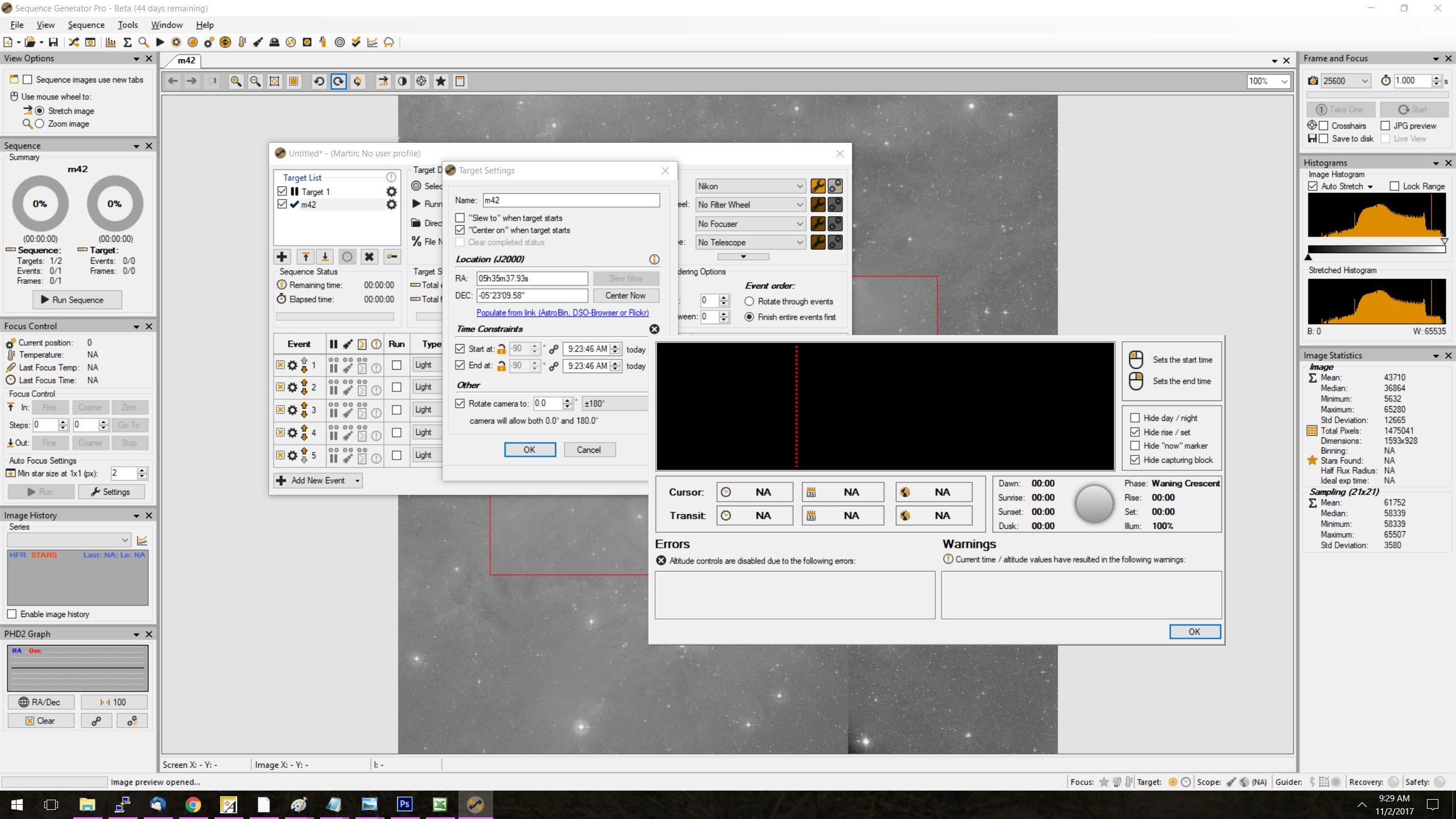
I have been using the new planning tool and wondered if the gradient sky background could be replaced by something like this :
This depicts the various zones (nautical, astro and civil). When I compare the threshold that SGP uses for its warning message, it falls between the times that Astroplanner uses. I often kick things off so that by the time the system has calibrated, focused and centered, it is dark enough for imaging - so I found myself backing up from the onset of the warning message . Excuse the graphic, it is just a poor sketch - it is mimicking the one in Astroplanner.
Where does it get the lat/long from? If it’s being read from the mount then that’s a bit of an issue for planning. I usually plan at my desk since I’m portable. If the mount has to be up and running that’s a bit of a bind, and really kills how useful this would be.
I did look and couldn’t see anywhere to manually set the lat/long.
I assume SGP is getting the Lat / Long from the User Profile assigned to the sequence. Make sure the user profile assigned to the sequence (File / Apply Profile To Sequence) has the correct Lat / Long defined. If you image from multiple locations, you would need to setup multiple user profiles corresponding to each of those locations and apply the correct one to the sequence.
Any chance we could get finer control over altitude? It looks like it’s limited to 1 degree increments. If, like me, you have trees near zenith, the difference between 80 and 80.5 can mean a significant amount of imaging.time. Maybe a tenth of a degree?
BTW, this is awesome. For people like me who image the same 3-5 targets a night for weeks or even months at a time (I have to do this because of trees), this saves a ton of error-prone keypunching. Thanks.
Kevin
Edit: How about if the graph is limited to one degree increments, but the user can input tenths of a degree in the target settings box?
Hello, I just downloaded 3.0.0.3 and tried the time planner but nothing appears for me, a small black (X) appears when I click “start at” then when I click the (X) the window opens but it’s all blank and I just get an error if I click around. Can anyone confirm that it is working ok?
This is the first time I am trying the new beta as well, so not sure if I missed something.
It appears you do not have a profile assigned to this sequence. SGP needs a properly completed and assigned profile to get location info. Without it, the Planning Assistant doesn’t know where you are and can’t create the graphic or fill in the boxes. At least one of your profiles needs to be marked as the default profile so that every new sequence you create has a profile assigned.
May i ask here a little feature request? it would be nice to have also moon’s altitude curve, becouse if i am shooting south i might collide with a full moon